Distance or length is one of the most important measurements. The transport, delivery, or courier companies use it to calculate the fare. Regular users also use the distance information to learn whether they’re heading in the right direction or whether they’re nearer to the destination or not. Professionals or students use it to calculate the area, etc. When it comes to the distance between two addresses, GPS plays a vital role in calculating the distance.
GPS is a technology with which we can get the exact latitude and longitude (coordinates) of a thing or a person. Once you have two latitudes and longitudes, you can calculate the distance using the Haversine formula (or similar formula). If the points are drawn on paper or you want to know the length or breadth of a small thing, you can use tape or a ruler. Well, you don’t have to use the formula or a ruler/tape if you have an Android or an iOS device. You can use your phone to find a distance in inches/centimeters between two points or the total area between multiple points. Below, I’ve shared a list of applications that can convert your phone into a ruler, distance measuring device, etc.
Best apps to measure distance and area
Google Maps

Google Maps displays the distance between two places on the map i.e. source and destination. You should use the application’s “direction” module to use this feature. This module asks you to enter the source and destination addresses. When you enter these two details, Google Maps highlights the route on the map and displays the total distance in meters/kilometers format. It also shows the directions you can follow to reach the destination and the total time you’ll spend on the roads. Another way to find the distance between two points is to use the application’s built-in “Measure” tool. How to access this tool? Long press on the map to choose point 1. Now, tap the box that Gmaps shows at the bottom of the screen and tap the “Measure” option. Now, select point 2. This Google app allows you to measure areas on a map too. To find the area using Google Maps, you must select at least three points on the map instead of two (the 3 points shouldn’t be in one line). Gmaps is powered by Google’s Geocoding and Geolocations API. It is a free service. Its official app ships with each Android device.
Why use Gmaps?
Most Play Store and iTunes applications use the Google Maps API in their code. Instead of using them, you can install and use GMaps. iOS users can use the Apple Maps application.
Ruler app
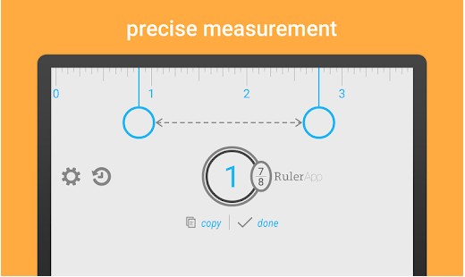
Google Maps lets you see the distance between two distant locations. If you want to measure the distance between two points on the floor, paper, or a plank, you should use the Ruler app. RA converts your smartphone into a ruler. You must choose one of these two units – centimeters or inches when you run it. Once you select the unit, RA will display a ruler on the screen. This ruler app for Android has an option to fix the ruler’s inaccuracy. It provides a history tool and an option to change the theme.
Waze
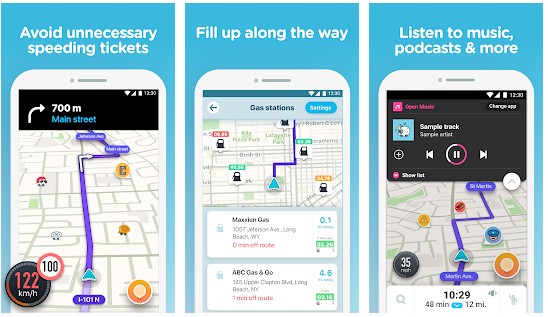
Waze is yet another great app for measuring the distance between a source and a destination. It has a report called “Free Driving Directions” that you can use to calculate the distance. This report is similar to Google Directions. Waze was an independent company until 2013. Google now owns it. Waze has its own map database.
The Route Planner feature of Here Maps
This feature of the Nokia owned Here Maps is similar to the directions module of Waze and Gmaps. Also, it is accurate. Like Waze and GMaps, Here has a massive database of maps, and it is popular in Europe.
Must Read: Best navigation apps
AR Ruler
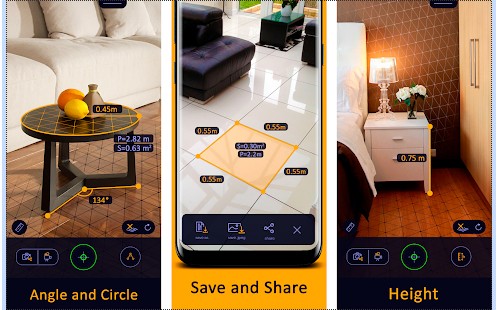
This measuring app uses Augmented Reality technology to make your phone’s camera a measuring device. To use it, your phone should support AR technology or must have the Google Core AR library. AR Ruler lets you measure the height of an object, and it can calculate the diameter of a circle, the surface area of a square, etc. ARR is an excellent app for users who often have to use mathematical formulas.
GPS Fields Area Measure

GPS Fields Area Measure is powered by the Google Maps API and has several features. It is one of the best measuring apps for Android, iPhone, and iPad. You’ll see a map and a round button with a plus sign icon when you run FAM. If you tap the icon, you’ll see the following options on the screen:
- Distance.
- Area.
- POI
The name of the options speaks for itself. If you choose the distance option, FAM will display a popup that asks you to select one of the following two options:
- Manual measuring.
- GPS Measuring.
Once you tap one of the above two options, you should select point A on the map by tapping on it. Then you must tap on point B (an area on the map). When you do so, GPS Fields Area Measure will display the distance between the two points on the map. This measuring app for iPhone, Android, and iPad lets you save the measurements and supports the following units:
- Square centimeter/meter/kilometers.
- Acre.
- Hectare.
- Meter.
- Kilometer.
Maps Measure

Maps Measure is a lightweight alternative to Fields Area Measure. Its size is below 1 megabyte. MM displays a map on the screen and a box at the center that shows the distance. The distance will be updated when you tap two or more points on the map. MM can highlight your current location on the map. Thus, finding the distance between your current location and another point is easy. Maps Measure can calculate the area of the selected region. It supports the undo operation. To unselect the map, tap the delete button.
Note: If you want to measure the distance you’ve walked or run, download and use one of these best running apps.


