Earthquakes or tsunamis caused by them are one of the primary reasons for deaths in the history of mankind. They’re caused when the massive rocks under the ground move or collide with each other. Although seismographs can instantly make you aware of an earthquake, unfortunately, there’s no way to determine when and where the plates will collide. One major calamity can cause another. If you’re staying nearby an ocean or a sea, an earthquake may trigger a tsunami. For example, in 2004, a quake in Indonesia of Richter scale 9.3 gave rise to a 100 feet Tsunami which killed around 200k people in South East Asia.
The best way to keep oneself safe is to move away from the place where seismic activity has been detected. To do so, you must either have a seismometer and a device that will play a sound when the seismometer detects unusual activity or use one of the five great earthquake alert/detector applications I’ve shared below.
Best earthquake apps for Android and iPhone
Earthquake Alert!
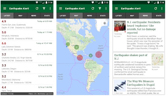
EAL has a tabbed interface. It displays a list of cities, the magnitude, and the earthquake’s depth in the latest section. You’ll find three vertical dots to the right side of the details. If you tap these dots, EAL will display an option to share the details, view the place on the map or USGS. If you want to know the damage the natural calamity has caused, you should open the “News” section. The app’s stats section shows the number of earthquakes that have occurred today, in the current week or month.
EAL also makes you aware of the largest earthquakes in the last seven days. It has a settings interface where you’ll find the options to change the default values of the distance, date, magnitude filters. This interface also displays options to show quake regions on the map, distance in KM/Miles from your location to the affected city, etc. By default, the Earthquake Alert! app sources data from the USGSGeo JSON file. You can change the data source to USGS CSV or Legacy CSV if you’re facing some problems with this source. EAL will display earthquake alerts only if you turn on the GPS module on your phone.
My Earthquake Alerts

MEA has ads, and it consumes more storage memory than the above application. If you’re looking for a simple app that highlights locations on the map and displays the places/cities where the earthquake has struck, you can use MEA. Like EA, the My Earthquake alerts app has location, Richter scale, and date filters. It also lets you sort the list by time, the distance away, and magnitude. MEA has details of earthquakes that struck between 1970 and the current year.
Must see: Best Android police scanner apps
Earthquake Network

EN is the 2nd most popular earthquake app on our list. It has a built-in real-time seismometer and an alert system that lets the phone display a small alert message and play sound during an earthquake. The seismometer shows two plain lines. The lines overlap each other. When you move or shake the phone, the red line will distort. The seismometer function works on phones equipped with an accelerometer sensor. You can configure the seismometer to function when the phone’s screen is off or run in the background when you’re not using the app.
EN gets data from various seismic networks. Once you choose a network, EN will display alerts from the selected country only. Earthquake Network enables you to discuss seismic activity with other users. Unregistered users can see chat messages only. They should register an account to participate in the discussion.
LastQuake

LastQuake is a 3.8 MB app that makes you aware of the latest earthquakes around you. It displays a list of seismic activities in the “Significant” section. If you tap the activity, LQ will show the following details on your screen:
- Distance.
- Latitude and longitude.
- Depth.
- Time.
- Richter scale
Below the above details, you’ll find the “I felt this earthquake” button. If you want to share your experience with other users, tap this button. LQ enables you to change the distance unit from kilometers to miles. You can configure it to show earthquakes within a certain distance from your location and of magnitude you specify.
Must read: Best GPS navigation apps
Twitter is not only a great social networking application but is also one of the first apps to display alerts of all types. When a natural calamity strikes a city, the people staying in the town will tweet about it. Twitter identifies the calamity and displays its name in the trending section. Twitter is used by major news publications, scientists, researchers, etc. Thus, the information shared by these folks on Twitter will be accurate.
Final thoughts: The five applications I’ve shared above are the best earthquake apps for Android and iOS operating systems.


